


पृथ्वी की स्थलाकृतियाँ – पर्वत, पठार एवं मैदान || Topography of the earth– Mountain, Plateau and Plain
निर्माण की प्रक्रिया के आधार पर पर्वतों को चार भागों में बाँटा जा सकता है -
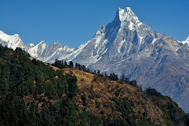
उदाहरण - हिमालय (एशिया), एंडीज (दक्षिण अमेरिका), रॉकी (उत्तरी अमेरिका) आदि। स्थलीय उच्चावच लक्षणों के आधार पर पर्वत एक ऐसा स्थान है, जिसके उच्चतम तथा निम्नतम भाग के मध्य सर्वाधिक अंतर होता है। धरातल के सभी उठे हुए भागों को पर्वत नहीं होते। किसी भी स्थल स्वरूप को पहचानने हेतु ऊँचाई तथा ढाल दोनों को सम्मिलित किया जाता है। उदाहरण के लिए तिब्बत के ऊपर उठी हुई भूमि पर्वत नहीं कही जाती, जबकि इसकी समुद्र तल से ऊँचाई लगभग 5000 मीटर है।
Mountains are plots that are much higher than near site figures. Their height is at least 500 meters. Their base is wide and the top is pointed. They are located in the form of long ranges and mountain clusters.
Examples - Himalaya (Asia), Andes (South America), Rocky (North America) etc. On the basis of terrestrial relief features, the mountain is such a place, which has the highest difference between the highest and the lowest part. Not all the raised parts of the surface are mountains. Both height and slope are included to identify any landmark. For example, the land raised above Tibet is not called a mountain, while its height is about 5000 meters above sea level.
निर्माण की प्रक्रिया के आधार पर पर्वतों को चार भागों में बाँटा जा सकता है -
Depending on the process of construction, the mountains can be divided into four parts -
1. वलित पर्वत (Vulture Mountains)- अभिसरण प्लेट सीमांत पर प्लेटो की टक्कर के कारण अधिक संपीडन बल के कारण वलन की प्रक्रिया से बनी स्थलाकृति को 'वलित पर्वत' अथवा 'मोड़ दार पर्वत' कहा जाता है।
उदाहरण - हिमालय, एंडीज, रॉकी पर्वत श्रृंखलाएँ आदि। संपूर्ण विश्व की सबसे ऊँची चोटियाँ इन्हीं नवीन मोड़दार पर्वतों में पाई जाती हैं।
The topography formed by the folding process due to greater compression force due to Plato's collision at the convergent plate frontier 'Vulture Mountains' or ' bend. The mountain is called '.
Examples - Himalayas, Andes, Rocky mountain ranges etc. The highest peaks of the whole world are found in these newly folded mountains.
2. ब्लॉक पर्वत (Block Mountains)- ब्लॉक पर्वत दो भ्रंश घाटियों के बीच अवस्थित शीर्ष स्थल खण्ड होते हैं। यहाँ यथावत स्थलखण्ड के दोनों किनारों पर तनावमूलक बल की वजह से अवतलन की प्रक्रिया से भ्रंश घाटीयाँ बन जाती हैं।
उदाहरण - साल्ट रेंज (पाकिस्तान), सतपुड़ा पर्वत (भारत) आदि। विश्व का सबसे अधिक विस्तृत ब्लॉक पर्वत केलिफोर्निया का 'सिएरा नेवादा' है।
Block Mountains are the top site blocks located between two fault basins. Here, due to the stressful force on both sides of the landmass, erratic basins are formed due to the process of concavity.
Examples - Salt Range (Pakistan), Satpura Mountains (India) etc. California's most extensive block mountain is 'Sierra Nevada' in California.
3. ज्वालामुखी पर्वत (Volcanic Mountains ) - ज्वालामुखी प्रक्रिया के फलस्वरुप उद्गार से निकले पदार्थों के जमाव से निर्मित शंकु अथवा पर्वत नुमा स्थलाकृति को 'ज्वालामुखी पर्वत' कहा जाता है।
उदाहरण - माउंट रेनियर (अमेरिका), माउंट फ्यूजीयामा (जापान), माउंट किलिमंजारो (तंजानिया) आदि।
The cone or mountain topography formed by the deposition of substances emanating as a result of the volcanic process is called the 'Volcanic Mountains'.
Examples - Mount Rainier (America), Mount Fujiyama (Japan), Mount Kilimanjaro (Tanzania) etc.
4. अवशिष्ट पर्वत (Residual Mountains) - ऐसे पर्वत जिनका अपरदन की क्रियाओं से अधिकांश भाग अपरदित हो चुका है तथा वर्तमान में सिर्फ उनका अवशेष ही अवस्थित हो, तो उन्हें 'अवशिष्ट पर्वत' कहा जाता है।
उदाहरण - अरावली (भारत), सतपुड़ा (भारत), विंध्यन (भारत), अपलेसियन पर्वत श्रेणी (अमेरिका) आदि।
Mountains that have been degraded for the most part by erosion actions and presently have only their remains, are called 'Residual Mountains'.
Examples - Aravalli (India), Satpura (India), Vindhyan (India), Apalesian mountain range (America) etc.
पठार (Plateau) - पठार पृथ्वी पर द्वितीय क्रम के उच्चावच होते हैं। ये आस-पास की सतह से ऊँचे होते हैं। सामान्यतः इनकी ऊंचाई सागर तल से 300 मीटर से 1000 मीटर होती है। इनकी शिखर सपाट तथा आधार अत्यधिक चौड़े एवं धार मंद होते हैं।
उदाहरण - दक्कन का पठार (भारत), तिब्बत का पठार (चीन), कोलंबिया का पठार आदि।
Plateaus are second-order reliefs on Earth. They are higher than the surrounding surface. Generally their height is 300 meters to 1000 meters above sea level. Their vertices are flat and the base is very wide and the edges are dim.
Examples - Deccan Plateau (India), Tibet Plateau (China), Columbia Plateau etc.
भौगोलिक स्थिति तथा संरचना के आधार पर पठारों को तीन भागों में बांटा जा सकता है -
On the basis of geographical location and structure, plateaus can be divided into three parts -
1. अंतरापर्वतीय पठार (Intercontinental Plateau )- ये पठार चारों ओर से ऊँची पर्वत श्रेणियों से गिरे हुए होते हैं। तिब्बत का पठार, बोलीविया का पठार आदि इसके उदाहरण हैं।
These plateaus are surrounded by high mountain ranges from all around. Examples are Plateau of Tibet, Plateau of Bolivia etc.
2. गिरिपदीय पठार (Giripadi Plateau )- ये पठार पर्वत की तलहटी में स्थित होते हैं। इनके दूसरी ओर समुद्र या मैदान होता है। पेटागोनिया का पठार (दक्षिण अमेरिका), पीडमाँड का पठार (उत्तर अमेरिका) आदि इसके उदाहरण हैं।
These plateaus are situated at the foot of the mountain. On the other side of them is the sea or the plain. Examples are Patagonia Plateau (South America), Piedmont Plateau (North America) etc. 3. महाद्वीपीय पठार (Continental Plateau ) - ये पठार धरातल की विस्तृत भू-भाग के ऊपर उठने के कारण बने होते हैं। इन पठारों को 'शील्ड' भी कहा जाता है। भारत का प्रायद्वीपीय पठार, कनाडियन शील्ड आदि इसके उदाहरण हैं।
These plateaus are formed due to the elevation of the vast terrain of the surface. These plateaus are also called 'shield' . Examples are Peninsular Plateau of India, Canadian Shield etc. विश्व के प्रमुख पठार (Major plateaus of the world) -
1. तिब्बत का पठार (मध्य एशिया)
2. भारतीय प्रायद्वीपीय पठार (भारत का दक्षिणी प्रायद्वीपीय भाग)
3. ग्रेट बेसिन पठार (संयुक्त राज्य अमेरिका)
4. मंगोलिया का पठार (उत्तरी मध्य चीन तथा मंगोलिया)
5. तुर्की अथवा अनातोलिया का पठार (तुर्की)
6. ऑस्ट्रेलिया का पठार (ऑस्ट्रेलिया)
7. यूनान का पठार (म्यांमार, चीन वियतनाम, लाओस)
8. कोलंबिया पठार (संयुक्त राज्य अमेरिका)
9. कोलोरैडो पठार (संयुक्त राज्य अमेरिका)
10. ग्रीनलैंड पठार (ग्रीनलैंड)
11. अबीसीनिया अथवा इथियोपिया का पठार (पूर्वी अफ्रीकी राज्यों इथियोपिया एवं सोमालिया में विस्तृत)
12. यूकाँन या अलास्का का पठार [अलास्का (संयुक्त राज्य अमेरिका)]
13. मेसेटा का पठार (स्पेन का आइबेरियन प्रायद्वीप)
1. Tibetan Plateau (Central Asia)
2. Indian Peninsular Plateau (Southern Peninsular part of India)
3. Great Basin Plateau (United States)
4. Mongolia Plateau (North Central China and Mongolia)
5. Turkey or Anatolia Plateau (Turkey)
6. Plateau of Australia (Australia)
7. Greece Plateau (Myanmar, China Vietnam, Laos)
8. Columbia Plateau (United States)
9. Colorado Plateau (United States)
10. Greenland Plateau (Greenland)
11. The plateau of Abyssinia or Ethiopia (detailed in the East African states of Ethiopia and Somalia)
12. Yucan or Alaska Plateau [Alaska (United States)]
13. Meseta Plateau (Spain's Iberian Peninsula)
मैदान (Plains) - मैदान सामान्यतः समतल भू-भाग होता है। इसकी ऊँचाई समुद्र तल से लगभग 150 मीटर होती है। अधिकतर मैदान नदियों द्वारा अपरदित पदार्थों (पत्थर, कंकड़, बालू आदि) के जमाव से बने होते हैं। जैसे - गंगा का मैदान (भारत), सिंधु का मैदान (भारत), ह्वांगहो का मैदान (चीन) आदि।
Plainss are generally flat terrain. Its height is about 150 meters above sea level. Most plains are made up of deposits of degraded materials (stones, pebbles, sand, etc.) by rivers. Such as - Gangetic Plain (India), Indus Plain (India), Hwanghao Plain (China) etc.
बनावट के आधार पर मैदानों को तीन भागों में बाँटा जा सकता है (Plains can be divided into three parts depending on the texture) -
1. संरचनात्मक मैदान (Structural Plains) - ये मैदान महाद्वीपीय निमग्न तट के उत्थान या भूमि के नीचे धँसने के कारण बनते हैं।
These plains are formed due to uplift of the continental submerged coast or subsidence below ground.
2. अपरदन द्वारा निर्मित मैदान (Plains formed by erosion) - ये मैदान पर्वत और पठारों के लंबे समय तक अपरदन से बनते हैं।
These plains are formed by prolonged erosion of mountains and plateaus.
3. निक्षेपणात्मक मैदान (Sedimentary Plain ) - ये मैदान अपरदन के कारकों (नदी, पवन, हिमानी आदि) के द्वारा प्रवाहित कर लाए गए पदार्थों के निक्षेपण से बने होते हैं। उदाहरण - गंगा का मैदान (जलोढ़ मृदा से निक्षेपण द्वारा निर्मित मैदान), लोएस मैदान (पवन द्वारा निर्मित मैदान) आदि।
These plains are made up of deposition of materials carried by erosion factors (river, wind, glacier etc.). Examples - Gangetic plain (plains formed by deposition from alluvial soil), Loess plain (plains formed by wind) etc.
RF competition
INFOSRF.COM
संबंधित जानकारी नीचे देखें।
(Watch related information below) 👇🏻

आशा है, उपरोक्त जानकारी उपयोगी एवं महत्वपूर्ण होगी।
(I hope the above information will be useful and important. )
Thank you.
लेखक
(Writer)
infosrf.com
पाठकों की टिप्पणियाॅं (0)
You may also like
यूरोप महाद्वीप के प्रमुख देश एवं उनकी राजधानियाँ | Europe's Main Countries And Their Capitals
यहाँ यूरोप महाद्वीप के प्रमुख देश एवं उनकी राजधानियाँ दी गई हैं। Europe's Main Countries And Their Capitals given here.
Read more
जर्मनी (यूरोप) की भौगोलिक एवं राजनीतिक विशेषताएँ | Geographical And Political Features Of Germany (Europe)
जर्मनी यूरोप महाद्वीप के महत्वपूर्ण देशों में से एक है। इसके उत्तर-पश्चिम में उत्तर सागर स्थित है। जर्मनी के उत्तर-पूर्व में बाल्टिक सागर स्थित है।
Read more.jpg)
फ्रांस (यूरोप) की भौगोलिक एवं राजनीतिक विशेषताएँ | Geographical And Political Features Of France (Europe)
फ्रांस क्षेत्रफल की दृष्टि से यूरोप महाद्वीप का दूसरा सबसे बड़ा देश है। यूरोप महाद्वीप का सबसे बड़ा देश रूस है।
Read more