


भारत का भूगोल : सिंधु नदी का अपवाह तंत्र
Geography of India : Drainage System of Indus River
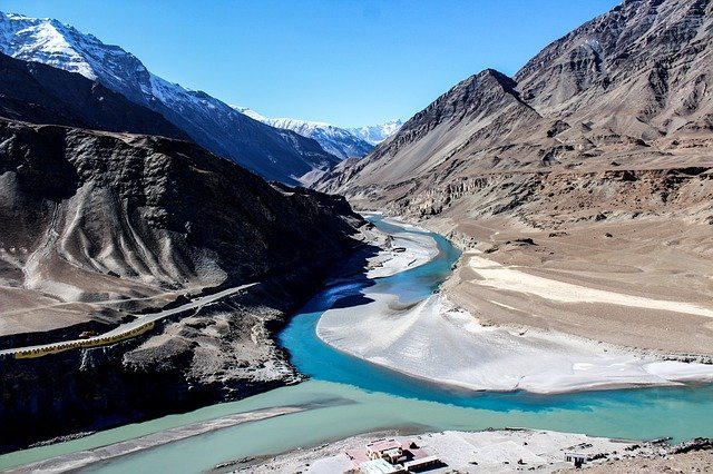
सिंधु नदी: का उद्गम कैलाश पर्वत में वह 'बोखर चू' के पास एक हिमनद से हुआ है। इस नदी को तिब्बत में 'शेर मुख' या 'सिंगी खंबान' के नाम से जाना जाता है। सिंधु नदी उद्गम के बाद लद्दाख तथा जास्कर श्रेणियों के मध्य से प्रवाहित होकर 'दमचोक' के पास से भारत में प्रवेश करती है। यह लद्दाख तथा गिलगित से प्रवाहित होने के दौरान गार्ज का निर्माण करती है। इसके बाद यह दर्दिस्तान में चिल्लड़ के निकट पाकिस्तान में प्रवेश करती है। सिंधु नदी की लंबाई 28,80 किलोमीटर है। इसमें से भारत में सिंधु की कुल लंबाई 11,14 किलोमीटर है। सिंधु नदी की अनेक सहायक नदियाँ हैं। उदाहरण - गिलगित, श्योक, काबुल, शिगार, पंचनद, जास्कर इत्यादि। पंचनद के अंतर्गत पाँच नदियाँ आती हैं ये नदियाँ हैं - झेलम, चिनाब, रावी, व्यास, सतलुज। इसकी अन्य सहायक नदियाँ - कुर्रम, तोची, गोमल, संगर और विबोआ है। ये सभी नदियाँ सुलेमान पर्वत से निकलती है। पंचनद नदियाँ आपस में मिलकर पाकिस्तान में 'मीथनकोट' के पास सिंधु नदी से मिलती हैं। सिंधु नदी का मुहाना अरब सागर में है। यह नदी भारत में केवल लद्दाख संघ राज्य क्षेत्र से प्रवाहित होती है। इस नदी के दाएँ तट पर भारत का लेह स्थित है। सिंधु नदी जल समझौते के अनुसार भारत विसर्जन क्षमता का केवल 20% भाग ही उपयोग कर सकता है। यह समझौता विभाजन के पश्चात सन् 1960 में हुआ था।
Indus River : It originates from a glacier near 'Bokhar Chu' in Mount Kailash. This river is known as 'Sher Mukh' or 'Singi Khamban' in Tibet. The Indus River flows through the Ladakh and Zaskar ranges after its origin and enters India from near 'Damchok' . It forms a guard while flowing through Ladakh and Gilgit. It then enters Pakistan near Chillad in Dardistan. The Indus River has a length of 28,80 km . Of this, the Indus has a total length of 11,14 km in India. The Indus River has several tributaries. Examples - Gilgit, Shyok, Kabul, Shigar, Panchanad, Zaskar etc. Five rivers fall under Panchanad . These rivers are - Jhelum, Chenab, Ravi, Vyas, Sutlej . Its other tributaries are - Kurram, Tochi, Gomal, Sangar and Viboa . All these rivers originate from Mount Sulaiman . The Panchanad rivers join the Indus river near 'Methankot' in Pakistan. The mouth of the Indus River is in the Arabian Sea. This river flows only from the Union Territory of Ladakh in India. Leh of India is situated on the right bank of this river. According to the Indus River Water Agreement, India can use only 20% of the immersion capacity. The agreement was signed after partition in 1960 .
झेलम नदी : इस नदी का उद्गम पीरपंजाल गिरी पद में अवस्थित वेरीनाग के पास 'शेषनाग झील' से हुआ है। यह नदी वूलर झील से होती हुई पाकिस्तान में चेनाब नदी में मिल जाती है। यह नदी श्रीनगर के निकट विसर्प का निर्माण करती है। पाकिस्तान में प्रवेश करने से पहले यह एक गहरी घाटी का निर्माण करती है। इस घाटी को 'बासमंगल' कहते हैं। पाकिस्तान में यह नदी 'मंगला डैम' का निर्माण करती है। जम्मू कश्मीर में यह नदी मुजफ्फराबाद से मीरपुर तक सीमा रेखा से होकर बहती है। झेलम नदी पर जम्मू कश्मीर में तुलबुल तथा उरी परियोजनाएँ चलाई जा रही है।
Jhelum River : The origin of this river is located in Pirpanjal Giri Pad near Verinag 'Sheshnag lake' . This river joins the Chenab River in Pakistan via the Wular lake. This river forms the Visarp near Srinagar. It forms a deep valley before entering Pakistan. This valley is called 'Basmangal' . In Pakistan, this river forms the 'Mangla Dam' . In Jammu and Kashmir this river flows through the border line from Muzaffarabad to Mirpur. The Tulbul and Uri projects in Jammu and Kashmir are being run on the Jhelum River.
चेनाब नदी : चेनाब नदी की भारत में कुल लंबाई 1,180 किलोमीटर है। यह सिंधु की सबसे बड़ी सहायक नदी है। हिमाचल प्रदेश में इससे 'चंद्रभागा' कहा जाता है। चेनाब नदी बारालाचा ला दर्रे के दोनों ओर से निकलने वाली दो नदियों चंद्र तथा भागा के केलांग के पास दांडी में मिलने से बनती है। यह नदी पीरपंजाल पर्वत के समानांतर कुछ दूरी तक पश्चिम में बहती है और किश्तवाड़ के निकट पीरपंजाल में एक गहरा गार्ज का निर्माण करती है। इसके बाद यह अखनूर के पास मैदान में प्रवेश करती है। इस नदी पर बगलिहार, सलाल और दुलहस्ती परियोजनाएँ चलाई जा रही हैं।
Chenab River : The Chenab River has a total length of 1,180 km in India. It is the largest tributary of the Indus. In Himachal Pradesh, it is called 'Chandrabhaga' . Near the Kelang of the Chandra and Bhaga , two rivers originating on either side of the Chenab River Baralacha La Pass . > Dandi . The river flows west some distance parallel to the Pirpanjal mountain and forms a deep GARGE at Pirpanjal near Kishtwar . It then enters the field near Akhnoor . Projects running Baglihar, Salal and Dulhasti are running on this river.
रावी नदी : इस नदी का उद्गम हिमाचल प्रदेश में रोहतांग दर्रे के पश्चिम से होता है। यह नदी चंबा घाटी में बहती है। यह पाकिस्तान में सराय सिंधु के निकट चेनाब नदी से मिल जाती है। यह सिंधु के बाएं तट पर मिलने वाली पांच नदियों में से एक नदी है। इस नदी पर निर्मित प्रमुख परियोजनाएं चमेरा तथा थीन हैं।
Ravi River : This river originates from the west of Rohtang Pass in Himachal Pradesh. The river flows into the Chamba Valley . It joins the Chenab River near Sarai Indus in Pakistan. It is one of the five rivers found on the left bank of the Indus. The major projects built on this river are Chamera and Thein .
व्यास नदी : यह नदी 'व्यास कुंड'<-b> से निकलती है, जो कि रोहतांग दर्रे के निकट अवस्थित है। यह हिमाचल प्रदेश के 'कुल्लू घाटी' से प्रवाहित होती है। यह धौलाधार श्रेणी में काफी तथा लारगी में गार्ज का निर्माण करती है। पंजाब में जाकर यह मैदानी भाग में प्रवेश करती है। यह हरिके नामक स्थान पर सतलुज नदी से मिलती है। इसके मिलन स्थान पर ही 'हरिके बैराज' का निर्माण हुआ है। हरिके बैराज से इंदिरा गाँधी नहर का निर्माण सिंचाई के लिए किया गया है। यह नहर भारत की सबसे लंबी नहर है। यह पंचनद की एकमात्र ऐसी नदी है जिसका प्रवाह केवल भारत में ही है।
Vyas River : This river originates from 'Vyas Kund' <- b>, which is located near Rohtang Pass. It flows through the 'Kullu Valley' of Himachal Pradesh. It forms a guard in the Dhauladhar category , coffee and largi . After entering Punjab, it enters the plains. It meets the Sutlej River at a place called Harike . 'Harike Barrage' has been built at its meeting point. The Indira Gandhi Canal from Harike Barrage has been constructed for irrigation. This canal is the longest canal in India. It is the only river in Panchanad that flows only in India.
सतलुज नदी : यह 'राक्षस ताल' झील से निकलती है, जो कि तिब्बत के पठार में अवस्थित है। तिब्बत में इसे 'लाँगचेन खंबाब' के नाम से जाना जाता है।यह भारत में प्रवेश करने के पूर्व सिंधु नदी के समानांतर प्रवाहित होती है। उसके बाद 'शिपकिला दर्रा' से होकर भारत में प्रवेश करती है। अपने उद्गम के पश्चात यह नदी पश्चिम दिशा में प्रवाहित होती है तथा हिमाचल प्रदेश में यह गहरी घाटी का निर्माण करती है। इस नदी की प्रमुख परियोजनाएँ भाखड़ा - नांगल परियोजना है। यह नदी फिरोजपुर से फाजिल्का के बीच भारत-पाकिस्तान की सीमा से होते हुए बहती है। भारत में इस नदी की लंबाई 10,50 किलोमीटर है, जबकि इस नदी की कुल लंबाई 14,50 किलोमीटर है।
Sutlej River : It originates from the 'Raksha Tal' lake, which is located in the Tibetan plateau. In Tibet it is known as 'Longchen Khambab' . It flows parallel to the Indus River before entering India. After that 'Shipkila Pass' enters India. After its origin, the river flows in the western direction and forms a deep valley in Himachal Pradesh. The major projects of this river are the Bhakra - Nangal project. This river flows through the Indo-Pakistan border between Ferozepur to Fazilka. The length of this river in India is 10,50 km , while the total length of this river is 14,50 km .
RF competition
INFOSRF.COM
संबंधित जानकारी नीचे देखें।
(Watch related information below) 👇🏻

आशा है, उपरोक्त जानकारी उपयोगी एवं महत्वपूर्ण होगी।
(I hope the above information will be useful and important. )
Thank you.
लेखक
(Writer)
infosrf.com
पाठकों की टिप्पणियाॅं (0)
You may also like
यूरोप महाद्वीप के प्रमुख देश एवं उनकी राजधानियाँ | Europe's Main Countries And Their Capitals
यहाँ यूरोप महाद्वीप के प्रमुख देश एवं उनकी राजधानियाँ दी गई हैं। Europe's Main Countries And Their Capitals given here.
Read more
जर्मनी (यूरोप) की भौगोलिक एवं राजनीतिक विशेषताएँ | Geographical And Political Features Of Germany (Europe)
जर्मनी यूरोप महाद्वीप के महत्वपूर्ण देशों में से एक है। इसके उत्तर-पश्चिम में उत्तर सागर स्थित है। जर्मनी के उत्तर-पूर्व में बाल्टिक सागर स्थित है।
Read more.jpg)
फ्रांस (यूरोप) की भौगोलिक एवं राजनीतिक विशेषताएँ | Geographical And Political Features Of France (Europe)
फ्रांस क्षेत्रफल की दृष्टि से यूरोप महाद्वीप का दूसरा सबसे बड़ा देश है। यूरोप महाद्वीप का सबसे बड़ा देश रूस है।
Read more